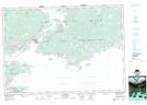
Maps showing Chapel Island 5, Richmond, Nova Scotia
Chapel Island 5 is a Indian Reserve located in Richmond, Nova Scotia.
- Latitude: 45° 41' 33'' North (decimal: 45.6924999)
- Longitude: 60° 45' 0'' West (decimal: -60.7500000)
- Topography Feature Category: Indian Reserve
- Geographical Feature: Indian Reserve - Réserve indienne
- Canadian Province/Territory: Nova Scotia
- Location: Richmond
- Atlas of Canada Locator Map: Chapel Island 5
- GPS Coordinate Locator Map: Chapel Island 5 Lat/Long