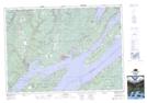
Maps showing Wagmatcook 1, Victoria, Nova Scotia
Wagmatcook 1 is a Indian Reserve located in Victoria, Nova Scotia.
- Latitude: 46° 4' 45'' North (decimal: 46.0791666)
- Longitude: 60° 55' 8'' West (decimal: -60.9188888)
- Topography Feature Category: Indian Reserve
- Geographical Feature: Indian Reserve - Réserve indienne
- Canadian Province/Territory: Nova Scotia
- Location: Victoria
- Atlas of Canada Locator Map: Wagmatcook 1
- GPS Coordinate Locator Map: Wagmatcook 1 Lat/Long