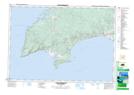
Maps showing Red River, Cumberland, Nova Scotia
Red River is a Unincorporated area located in Cumberland, Nova Scotia.
- Latitude: 45° 26' 49'' North (decimal: 45.4468998)
- Longitude: 64° 39' 5'' West (decimal: -64.6513999)
- Topography Feature Category: Unincorporated area
- Geographical Feature: Woodland Area
- Canadian Province/Territory: Nova Scotia
- Location: Cumberland
- Atlas of Canada Locator Map: Red River
- GPS Coordinate Locator Map: Red River Lat/Long
Red River NTS Map Sheets