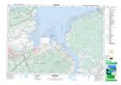
Maps showing Glooscap 35, Kings, Nova Scotia
Glooscap 35 is a Indian Reserve located in Kings, Nova Scotia.
- Latitude: 45° 2' 32'' North (decimal: 45.0422221)
- Longitude: 64° 15' 43'' West (decimal: -64.2619443)
- Topography Feature Category: Indian Reserve
- Geographical Feature: Indian Reserve - Réserve indienne
- Canadian Province/Territory: Nova Scotia
- Location: Kings
- Atlas of Canada Locator Map: Glooscap 35
- GPS Coordinate Locator Map: Glooscap 35 Lat/Long