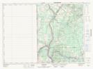
Maps showing Aroostook, Victoria, New Brunswick
Aroostook is a Village located in Victoria, New Brunswick and has an elevation of 103 meters.
- Latitude: 46° 48' 21'' North (decimal: 46.8059328)
- Longitude: 67° 43' 26'' West (decimal: -67.7239323)
- Topography Feature Category: Village
- Geographical Feature: Village
- Canadian Province/Territory: New Brunswick
- Elevation: 103 meters
- Location: Victoria
- Atlas of Canada Locator Map: Aroostook
- GPS Coordinate Locator Map: Aroostook Lat/Long
Aroostook NTS Map Sheets