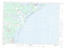
Maps showing Sainte-Rose-Gloucester, Gloucester, New Brunswick
Sainte-Rose-Gloucester is a Unincorporated area located in Gloucester, New Brunswick and has an elevation of 22 meters.
- Latitude: 47° 37' 7'' North (decimal: 47.6186614)
- Longitude: 64° 55' 59'' West (decimal: -64.9331857)
- Topography Feature Category: Unincorporated area
- Geographical Feature: Dispersed Rural Community
- Canadian Province/Territory: New Brunswick
- Elevation: 22 meters
- Location: Gloucester
- Atlas of Canada Locator Map: Sainte-Rose-Gloucester
- GPS Coordinate Locator Map: Sainte-Rose-Gloucester Lat/Long