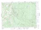
Maps showing Cedar Lake, York, New Brunswick
Cedar Lake is a Lake located in York, New Brunswick and has an elevation of 374 meters.
- Latitude: 46° 20' 38'' North (decimal: 46.3439141)
- Longitude: 67° 12' 11'' West (decimal: -67.203003)
- Topography Feature Category: Lake
- Geographical Feature: Lake
- Canadian Province/Territory: New Brunswick
- Elevation: 374 meters
- Location: York
- Atlas of Canada Locator Map: Cedar Lake
- GPS Coordinate Locator Map: Cedar Lake Lat/Long
Cedar Lake NTS Map Sheets