Maps showing Florenceville, Carleton, New Brunswick
Florenceville is a Village located in Carleton, New Brunswick and has an elevation of 70 meters.
- Latitude: 46° 26' 29'' North (decimal: 46.4414625)
- Longitude: 67° 37' 10'' West (decimal: -67.6193241)
- Topography Feature Category: Village
- Geographical Feature: Village
- Canadian Province/Territory: New Brunswick
- Elevation: 70 meters
- Location: Carleton
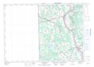
- Atlas of Canada Locator Map: Florenceville
- GPS Coordinate Locator Map: Florenceville Lat/Long
Florenceville NTS Map Sheets