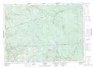
Maps showing Foreston, Carleton, New Brunswick
Foreston is a Unincorporated area located in Carleton, New Brunswick and has an elevation of 289 meters.
- Latitude: 46° 31' 42'' North (decimal: 46.5283617)
- Longitude: 67° 18' 32'' West (decimal: -67.3089108)
- Topography Feature Category: Unincorporated area
- Geographical Feature: Dispersed Rural Community
- Canadian Province/Territory: New Brunswick
- Elevation: 289 meters
- Location: Carleton
- Atlas of Canada Locator Map: Foreston
- GPS Coordinate Locator Map: Foreston Lat/Long