Maps showing Hugh John Flemming Bridge, Carleton, New Brunswick
Hugh John Flemming Bridge is a Road feature located in Carleton, New Brunswick and has an elevation of 62 meters.
- Latitude: 46° 18' 14'' North (decimal: 46.3037918)
- Longitude: 67° 32' 20'' West (decimal: -67.5389785)
- Topography Feature Category: Road feature
- Geographical Feature: Bridge
- Canadian Province/Territory: New Brunswick
- Elevation: 62 meters
- Location: Carleton
- Atlas of Canada Locator Map: Hugh John Flemming Bridge
- GPS Coordinate Locator Map: Hugh John Flemming Bridge Lat/Long
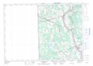
Hugh John Flemming Bridge NTS Map Sheets