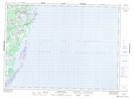
Maps showing MacWilliams Marsh, Northumberland, New Brunswick
MacWilliams Marsh is a Low vegetation located in Northumberland, New Brunswick and has an elevation of 1 meters.
- Latitude: 47° 23' 36'' North (decimal: 47.3934243)
- Longitude: 64° 54' 26'' West (decimal: -64.9072925)
- Topography Feature Category: Low vegetation
- Geographical Feature: Marsh
- Canadian Province/Territory: New Brunswick
- Elevation: 1 meters
- Location: Northumberland
- Atlas of Canada Locator Map: MacWilliams Marsh
- GPS Coordinate Locator Map: MacWilliams Marsh Lat/Long
MacWilliams Marsh NTS Map Sheets