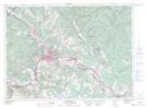
Maps showing Daigle Island, Madawaska, New Brunswick
Daigle Island is a Island located in Madawaska, New Brunswick and has an elevation of 155 meters.
- Latitude: 47° 17' 50'' North (decimal: 47.2973359)
- Longitude: 68° 29' 31'' West (decimal: -68.4919097)
- Topography Feature Category: Island
- Geographical Feature: Island
- Canadian Province/Territory: New Brunswick
- Elevation: 155 meters
- Location: Madawaska
- Atlas of Canada Locator Map: Daigle Island
- GPS Coordinate Locator Map: Daigle Island Lat/Long
Daigle Island NTS Map Sheets