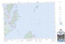
Maps showing Sugar Loaf Rock, Charlotte, New Brunswick
Sugar Loaf Rock is a Shoal located in Charlotte, New Brunswick and has an elevation of 3 meters.
- Latitude: 44° 49' 49'' North (decimal: 44.8304085)
- Longitude: 66° 55' 38'' West (decimal: -66.927299)
- Topography Feature Category: Shoal
- Geographical Feature: Rock
- Canadian Province/Territory: New Brunswick
- Elevation: 3 meters
- Location: Charlotte
- Atlas of Canada Locator Map: Sugar Loaf Rock
- GPS Coordinate Locator Map: Sugar Loaf Rock Lat/Long
Sugar Loaf Rock NTS Map Sheets