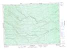
Maps showing Whitney Pond, Northumberland, New Brunswick
Whitney Pond is a Lake located in Northumberland, New Brunswick and has an elevation of 338 meters.
- Latitude: 46° 59' 44'' North (decimal: 46.9955016)
- Longitude: 66° 19' 21'' West (decimal: -66.3224669)
- Topography Feature Category: Lake
- Geographical Feature: Pond
- Canadian Province/Territory: New Brunswick
- Elevation: 338 meters
- Location: Northumberland
- Atlas of Canada Locator Map: Whitney Pond
- GPS Coordinate Locator Map: Whitney Pond Lat/Long
Whitney Pond NTS Map Sheets