Maps showing Rang-Cinq-Et-Six, Restigouche, New Brunswick
Rang-Cinq-Et-Six is a Unincorporated area located in Restigouche, New Brunswick and has an elevation of 258 meters.
- Latitude: 47° 31' 13'' North (decimal: 47.5202246)
- Longitude: 67° 30' 7'' West (decimal: -67.5018814)
- Topography Feature Category: Unincorporated area
- Geographical Feature: Dispersed Rural Community
- Canadian Province/Territory: New Brunswick
- Elevation: 258 meters
- Location: Restigouche
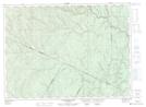
- Atlas of Canada Locator Map: Rang-Cinq-Et-Six
- GPS Coordinate Locator Map: Rang-Cinq-Et-Six Lat/Long
Rang-Cinq-Et-Six NTS Map Sheets