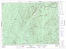
Maps showing Bald Peak, Victoria, New Brunswick
Bald Peak is a Mountain located in Victoria, New Brunswick and has an elevation of 426 meters.
- Latitude: 47° 10' 23'' North (decimal: 47.1730728)
- Longitude: 67° 6' 30'' West (decimal: -67.1084394)
- Topography Feature Category: Mountain
- Geographical Feature: Peak
- Canadian Province/Territory: New Brunswick
- Elevation: 426 meters
- Location: Victoria
- Atlas of Canada Locator Map: Bald Peak
- GPS Coordinate Locator Map: Bald Peak Lat/Long
Bald Peak NTS Map Sheets