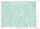
Maps showing Ruisseau Alder, Lac-Douaire; Antoine-Labelle, Quebec
Ruisseau Alder is a River located in Lac-Douaire; Antoine-Labelle, Quebec and has an elevation of 373 meters.
- Latitude: 46° 52' 7'' North (decimal: 46.8686655)
- Longitude: 74° 56' 33'' West (decimal: -74.9424015)
- Topography Feature Category: River
- Geographical Feature: Ruisseau
- Canadian Province/Territory: Quebec
- Elevation: 373 meters
- Location: Lac-Douaire; Antoine-Labelle
- Atlas of Canada Locator Map: Ruisseau Alder
- GPS Coordinate Locator Map: Ruisseau Alder Lat/Long
Ruisseau Alder NTS Map Sheets