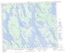
Maps showing Pointe de Cailloux, Rivière-Mouchalagane; Caniapiscau, Quebec
Pointe de Cailloux is a Cape located in Rivière-Mouchalagane; Caniapiscau, Quebec.
- Latitude: 52° 54' 50'' North (decimal: 52.9138889)
- Longitude: 66° 13' 40'' West (decimal: -66.2277778)
- Topography Feature Category: Cape
- Geographical Feature: Pointe
- Canadian Province/Territory: Quebec
- Location: Rivière-Mouchalagane; Caniapiscau
- Atlas of Canada Locator Map: Pointe de Cailloux
- GPS Coordinate Locator Map: Pointe de Cailloux Lat/Long
Pointe de Cailloux NTS Map Sheets