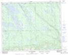
Maps showing Petit lac des Cèdres, Rivière-Mouchalagane; Caniapiscau, Quebec
Petit lac des Cèdres is a Lake located in Rivière-Mouchalagane; Caniapiscau, Quebec and has an elevation of 501 meters.
- Latitude: 51° 57' 42'' North (decimal: 51.9616666)
- Longitude: 67° 4' 3'' West (decimal: -67.0675000)
- Topography Feature Category: Lake
- Geographical Feature: Lac
- Canadian Province/Territory: Quebec
- Elevation: 501 meters
- Location: Rivière-Mouchalagane; Caniapiscau
- Atlas of Canada Locator Map: Petit lac des Cèdres
- GPS Coordinate Locator Map: Petit lac des Cèdres Lat/Long
Petit lac des Cèdres NTS Map Sheets