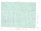
Maps showing Baie des Cinq Milles, Lac-Nilgaut; Pontiac, Quebec
Baie des Cinq Milles is a Bay located in Lac-Nilgaut; Pontiac, Quebec and has an elevation of 270 meters.
- Latitude: 46° 24' 17'' North (decimal: 46.4047222)
- Longitude: 76° 56' 29'' West (decimal: -76.9413889)
- Topography Feature Category: Bay
- Geographical Feature: Baie
- Canadian Province/Territory: Quebec
- Elevation: 270 meters
- Location: Lac-Nilgaut; Pontiac
- Atlas of Canada Locator Map: Baie des Cinq Milles
- GPS Coordinate Locator Map: Baie des Cinq Milles Lat/Long
Baie des Cinq Milles NTS Map Sheets