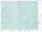
Maps showing Barrage Daniel-Johnson, Rivière-aux-Outardes; Manicouagan, Quebec
Barrage Daniel-Johnson is a Hydraulic construction located in Rivière-aux-Outardes; Manicouagan, Quebec and has an elevation of 289 meters.
- Latitude: 50° 38' 49'' North (decimal: 50.6469659)
- Longitude: 68° 43' 25'' West (decimal: -68.7236931)
- Topography Feature Category: Hydraulic construction
- Geographical Feature: Barrage
- Canadian Province/Territory: Quebec
- Elevation: 289 meters
- Location: Rivière-aux-Outardes; Manicouagan
- Atlas of Canada Locator Map: Barrage Daniel-Johnson
- GPS Coordinate Locator Map: Barrage Daniel-Johnson Lat/Long
Barrage Daniel-Johnson NTS Map Sheets