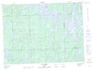
Maps showing Rivière de l'Esturgeon, Rivière-Kipawa; Témiscamingue, Quebec
Rivière de l'Esturgeon is a River located in Rivière-Kipawa; Témiscamingue, Quebec and has an elevation of 337 meters.
- Latitude: 47° 34' 24'' North (decimal: 47.5734093)
- Longitude: 78° 11' 44'' West (decimal: -78.1956041)
- Topography Feature Category: River
- Geographical Feature: Rivière
- Canadian Province/Territory: Quebec
- Elevation: 337 meters
- Location: Rivière-Kipawa; Témiscamingue
- Atlas of Canada Locator Map: Rivière de l'Esturgeon
- GPS Coordinate Locator Map: Rivière de l'Esturgeon Lat/Long
Rivière de l'Esturgeon NTS Map Sheets