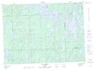
Maps showing Pointe Fagarty, Rouyn-Noranda; Rouyn-Noranda, Quebec
Pointe Fagarty is a Cape located in Rouyn-Noranda; Rouyn-Noranda, Quebec and has an elevation of 322 meters.
- Latitude: 47° 44' 46'' North (decimal: 47.7461111)
- Longitude: 78° 17' 25'' West (decimal: -78.2902778)
- Topography Feature Category: Cape
- Geographical Feature: Pointe
- Canadian Province/Territory: Quebec
- Elevation: 322 meters
- Location: Rouyn-Noranda; Rouyn-Noranda
- Atlas of Canada Locator Map: Pointe Fagarty
- GPS Coordinate Locator Map: Pointe Fagarty Lat/Long
Pointe Fagarty NTS Map Sheets