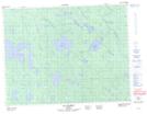
Maps showing Lac Louis, Baie-James; Jamésie, Quebec
Lac Louis is a Lake located in Baie-James; Jamésie, Quebec.
- Latitude: 50° 27' 34'' North (decimal: 50.4593999)
- Longitude: 78° 12' 35'' West (decimal: -78.2096999)
- Topography Feature Category: Lake
- Geographical Feature: Lac
- Canadian Province/Territory: Quebec
- Location: Baie-James; Jamésie
- GPS Coordinate Locator Map: Lac Louis Lat/Long
Lac Louis NTS Map Sheets