Canada Topographic Maps

Lac Moinier Topo Maps

Topography maps and Latitude/Longitude Location

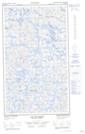
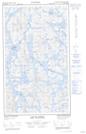
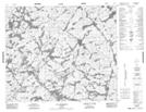
Maps showing Lac Moinier, Caniapiscau; Caniapiscau, Quebec

Lac Moinier is a Lake located in Caniapiscau; Caniapiscau, Quebec.

  • Latitude: 54° 18' 21'' North   (decimal: 54.3058333)
  • Longitude: 67° 58' 12'' West   (decimal: -67.97)
  • Topography Feature Category: Lake
  • Geographical Feature: Lac
  • Canadian Province/Territory: Quebec
  • Location: Caniapiscau; Caniapiscau
  • Atlas of Canada Locator Map: Lac Moinier
  • GPS Coordinate Locator Map: Lac Moinier Lat/Long

Lac Moinier NTS Map Sheets

023J05E Sandy Lake Topographic Map at 1:50,000 scale

023J05W Sandy Lake Topographic Map at 1:50,000 scale

023K08 Lac Delornieu Topographic Map at 1:50,000 scale

023J Schefferville Topographic Map at 1:250,000 scale

023K Caniapiscau Topographic Map at 1:250,000 scale

 
Buy Topographic Maps DVD
Newsletter Sign-up

Yes, I want to receive map store discounts.


Bookmark and Share