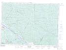
Maps showing Rocher à l'Oiseau, Sheenboro; Pontiac, Quebec
Rocher à l'Oiseau is a Island located in Sheenboro; Pontiac, Quebec and has an elevation of 135 meters.
- Latitude: 46° 2' 6'' North (decimal: 46.035)
- Longitude: 77° 18' 40'' West (decimal: -77.3111111)
- Topography Feature Category: Island
- Geographical Feature: Rocher
- Canadian Province/Territory: Quebec
- Elevation: 135 meters
- Location: Sheenboro; Pontiac
- Atlas of Canada Locator Map: Rocher à l'Oiseau
- GPS Coordinate Locator Map: Rocher à l'Oiseau Lat/Long
Rocher à l'Oiseau NTS Map Sheets