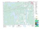
Maps showing Lac Ollier, Rouyn-Noranda; Rouyn-Noranda, Quebec
Lac Ollier is a Lake located in Rouyn-Noranda; Rouyn-Noranda, Quebec and has an elevation of 285 meters.
- Latitude: 48° 10' 17'' North (decimal: 48.1713889)
- Longitude: 79° 16' 55'' West (decimal: -79.2819444)
- Topography Feature Category: Lake
- Geographical Feature: Lac
- Canadian Province/Territory: Quebec
- Elevation: 285 meters
- Location: Rouyn-Noranda; Rouyn-Noranda
- Atlas of Canada Locator Map: Lac Ollier
- GPS Coordinate Locator Map: Lac Ollier Lat/Long
Lac Ollier NTS Map Sheets