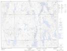
Maps showing Lac de la Perdrix Blanche, Rivière-Mouchalagane; Caniapiscau, Quebec
Lac de la Perdrix Blanche is a Lake located in Rivière-Mouchalagane; Caniapiscau, Quebec and has an elevation of 661 meters.
- Latitude: 52° 16' 43'' North (decimal: 52.2786110)
- Longitude: 68° 22' 55'' West (decimal: -68.3819444)
- Topography Feature Category: Lake
- Geographical Feature: Lac
- Canadian Province/Territory: Quebec
- Elevation: 661 meters
- Location: Rivière-Mouchalagane; Caniapiscau
- Atlas of Canada Locator Map: Lac de la Perdrix Blanche
- GPS Coordinate Locator Map: Lac de la Perdrix Blanche Lat/Long
Lac de la Perdrix Blanche NTS Map Sheets