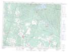
Maps showing Portage-Lapointe, Saguenay; Saguenay, Quebec
Portage-Lapointe is a Unincorporated area located in Saguenay; Saguenay, Quebec and has an elevation of 122 meters.
- Latitude: 48° 33' 4'' North (decimal: 48.5511111)
- Longitude: 71° 15' 3'' West (decimal: -71.2508333)
- Topography Feature Category: Unincorporated area
- Geographical Feature: Lieu-dit
- Canadian Province/Territory: Quebec
- Elevation: 122 meters
- Location: Saguenay; Saguenay
- Atlas of Canada Locator Map: Portage-Lapointe
- GPS Coordinate Locator Map: Portage-Lapointe Lat/Long
Portage-Lapointe NTS Map Sheets