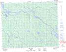
Maps showing Rivière Richerville, Baie-James; Jamésie, Quebec
Rivière Richerville is a River located in Baie-James; Jamésie, Quebec and has an elevation of 120 meters.
- Latitude: 50° 56' 26'' North (decimal: 50.9405556)
- Longitude: 78° 20' 43'' West (decimal: -78.3452778)
- Topography Feature Category: River
- Geographical Feature: Rivière
- Canadian Province/Territory: Quebec
- Elevation: 120 meters
- Location: Baie-James; Jamésie
- Atlas of Canada Locator Map: Rivière Richerville
- GPS Coordinate Locator Map: Rivière Richerville Lat/Long
Rivière Richerville NTS Map Sheets