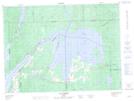
Maps showing Lac Simard, Laforce; Témiscamingue, Quebec
Lac Simard is a Lake located in Laforce; Témiscamingue, Quebec and has an elevation of 244 meters.
- Latitude: 47° 37' 46'' North (decimal: 47.6294444)
- Longitude: 78° 41' 26'' West (decimal: -78.6905556)
- Topography Feature Category: Lake
- Geographical Feature: Lac
- Canadian Province/Territory: Quebec
- Elevation: 244 meters
- Location: Laforce; Témiscamingue
- Atlas of Canada Locator Map: Lac Simard
- GPS Coordinate Locator Map: Lac Simard Lat/Long
Lac Simard NTS Map Sheets