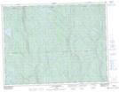
Maps showing Lac Claude, Rivière-Mistassini; Maria-Chapdelaine, Quebec
Lac Claude is a Lake located in Rivière-Mistassini; Maria-Chapdelaine, Quebec and has an elevation of 298 meters.
- Latitude: 49° 17' 47'' North (decimal: 49.2963889)
- Longitude: 72° 47' 49'' West (decimal: -72.7969444)
- Topography Feature Category: Lake
- Geographical Feature: Lac
- Canadian Province/Territory: Quebec
- Elevation: 298 meters
- Location: Rivière-Mistassini; Maria-Chapdelaine
- Atlas of Canada Locator Map: Lac Claude
- GPS Coordinate Locator Map: Lac Claude Lat/Long
Lac Claude NTS Map Sheets