Maps showing Île Moukmouk, Duparquet; Abitibi-Ouest, Quebec
Île Moukmouk is a Island located in Duparquet; Abitibi-Ouest, Quebec and has an elevation of 273 meters.
- Latitude: 48° 27' 5'' North (decimal: 48.4513889)
- Longitude: 79° 15' 42'' West (decimal: -79.2616667)
- Topography Feature Category: Island
- Geographical Feature: Île / Ile
- Canadian Province/Territory: Quebec
- Elevation: 273 meters
- Location: Duparquet; Abitibi-Ouest
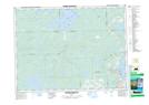
- Atlas of Canada Locator Map: Île Moukmouk
- GPS Coordinate Locator Map: Île Moukmouk Lat/Long
Île Moukmouk NTS Map Sheets