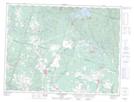
Maps showing Ruisseau Thomas-Néron, Bégin; Le Fjord-du-Saguenay, Quebec
Ruisseau Thomas-Néron is a River located in Bégin; Le Fjord-du-Saguenay, Quebec.
- Latitude: 48° 37' 33'' North (decimal: 48.6258333)
- Longitude: 71° 16' 5'' West (decimal: -71.2680556)
- Topography Feature Category: River
- Geographical Feature: Ruisseau
- Canadian Province/Territory: Quebec
- Location: Bégin; Le Fjord-du-Saguenay
- GPS Coordinate Locator Map: Ruisseau Thomas-Néron Lat/Long
Ruisseau Thomas-Néron NTS Map Sheets