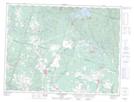
Maps showing Ruisseau de l'Éclair, Saint-Honoré; Le Fjord-du-Saguenay, Quebec
Ruisseau de l'Éclair is a River located in Saint-Honoré; Le Fjord-du-Saguenay, Quebec and has an elevation of 109 meters.
- Latitude: 48° 30' 20'' North (decimal: 48.5055985)
- Longitude: 71° 9' 30'' West (decimal: -71.1584232)
- Topography Feature Category: River
- Geographical Feature: Ruisseau
- Canadian Province/Territory: Quebec
- Elevation: 109 meters
- Location: Saint-Honoré; Le Fjord-du-Saguenay
- Atlas of Canada Locator Map: Ruisseau de l'Éclair
- GPS Coordinate Locator Map: Ruisseau de l'Éclair Lat/Long
Ruisseau de l'Éclair NTS Map Sheets