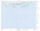
Maps showing Chenal des Saints, Havre-Saint-Pierre; Minganie, Quebec
Chenal des Saints is a Channel located in Havre-Saint-Pierre; Minganie, Quebec.
- Latitude: 50° 14' 6'' North (decimal: 50.235)
- Longitude: 63° 5' 36'' West (decimal: -63.0933333)
- Topography Feature Category: Channel
- Geographical Feature: Chenal
- Canadian Province/Territory: Quebec
- Location: Havre-Saint-Pierre; Minganie
- GPS Coordinate Locator Map: Chenal des Saints Lat/Long
Chenal des Saints NTS Map Sheets