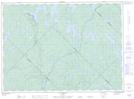
Maps showing Atitetamini Sakahikan, Lac-De La Bidière; Antoine-Labelle, Quebec
Atitetamini Sakahikan is a Lake located in Lac-De La Bidière; Antoine-Labelle, Quebec.
- Latitude: 47° 7' 25'' North (decimal: 47.1236676)
- Longitude: 74° 27' 25'' West (decimal: -74.4568196)
- Topography Feature Category: Lake
- Geographical Feature: Lac
- Canadian Province/Territory: Quebec
- Location: Lac-De La Bidière; Antoine-Labelle
- GPS Coordinate Locator Map: Atitetamini Sakahikan Lat/Long
Atitetamini Sakahikan NTS Map Sheets