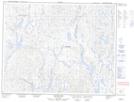
Maps showing Uhatnihip, Lac-Jérôme; Minganie, Quebec
Uhatnihip is a Unincorporated area located in Lac-Jérôme; Minganie, Quebec.
- Latitude: 51° 37' 22'' North (decimal: 51.6228418)
- Longitude: 64° 14' 22'' West (decimal: -64.2395745)
- Topography Feature Category: Unincorporated area
- Geographical Feature: Lieu-dit
- Canadian Province/Territory: Quebec
- Location: Lac-Jérôme; Minganie
- Atlas of Canada Locator Map: Uhatnihip
- GPS Coordinate Locator Map: Uhatnihip Lat/Long
Uhatnihip NTS Map Sheets