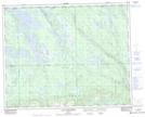
Maps showing Portage Kaupuameu, Rivière-Mouchalagane; Caniapiscau, Quebec
Portage Kaupuameu is a Road feature located in Rivière-Mouchalagane; Caniapiscau, Quebec.
- Latitude: 51° 56' 42'' North (decimal: 51.9450000)
- Longitude: 67° 19' 39'' West (decimal: -67.3274999)
- Topography Feature Category: Road feature
- Geographical Feature: Portage
- Canadian Province/Territory: Quebec
- Location: Rivière-Mouchalagane; Caniapiscau
- Atlas of Canada Locator Map: Portage Kaupuameu
- GPS Coordinate Locator Map: Portage Kaupuameu Lat/Long
Portage Kaupuameu NTS Map Sheets