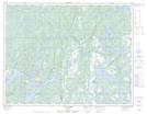
Maps showing Lac Hélène, Havre-Saint-Pierre; Minganie, Quebec
Lac Hélène is a Lake located in Havre-Saint-Pierre; Minganie, Quebec.
- Latitude: 50° 32' 28'' North (decimal: 50.5411111)
- Longitude: 63° 19' 38'' West (decimal: -63.3272222)
- Topography Feature Category: Lake
- Geographical Feature: Lac
- Canadian Province/Territory: Quebec
- Location: Havre-Saint-Pierre; Minganie
- Atlas of Canada Locator Map: Lac Hélène
- GPS Coordinate Locator Map: Lac Hélène Lat/Long
Lac Hélène NTS Map Sheets