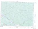
Maps showing LacNadeau, Sheenboro; Pontiac, Quebec
LacNadeau is a Lake located in Sheenboro; Pontiac, Quebec and has an elevation of 304 meters.
- Latitude: 46° 5' 16'' North (decimal: 46.0877778)
- Longitude: 77° 11' 28'' West (decimal: -77.1911111)
- Topography Feature Category: Lake
- Geographical Feature: Lac
- Canadian Province/Territory: Quebec
- Elevation: 304 meters
- Location: Sheenboro; Pontiac
- Atlas of Canada Locator Map: LacNadeau
- GPS Coordinate Locator Map: LacNadeau Lat/Long
LacNadeau NTS Map Sheets