Maps showing Île Matenen, La Tuque; Le Haut-Saint-Maurice, Quebec
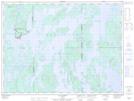
Île Matenen is a Island located in La Tuque; Le Haut-Saint-Maurice, Quebec.
- Latitude: 48° 40' 32'' North (decimal: 48.6755556)
- Longitude: 74° 53' 21'' West (decimal: -74.8891667)
- Topography Feature Category: Island
- Geographical Feature: Île / Ile
- Canadian Province/Territory: Quebec
- Location: La Tuque; Le Haut-Saint-Maurice
- Atlas of Canada Locator Map: Île Matenen
- GPS Coordinate Locator Map: Île Matenen Lat/Long
Île Matenen NTS Map Sheets