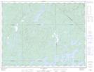
Maps showing Lac Kanicokohotew, La Tuque; Le Haut-Saint-Maurice, Quebec
Lac Kanicokohotew is a Lake located in La Tuque; Le Haut-Saint-Maurice, Quebec.
- Latitude: 48° 55' 36'' North (decimal: 48.9266667)
- Longitude: 74° 50' 33'' West (decimal: -74.8425)
- Topography Feature Category: Lake
- Geographical Feature: Lac
- Canadian Province/Territory: Quebec
- Location: La Tuque; Le Haut-Saint-Maurice
- GPS Coordinate Locator Map: Lac Kanicokohotew Lat/Long
Lac Kanicokohotew NTS Map Sheets