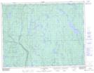
Maps showing Montagne Plate, Rivière-Mistassini; Maria-Chapdelaine, Quebec
Montagne Plate is a Mountain located in Rivière-Mistassini; Maria-Chapdelaine, Quebec and has an elevation of 395 meters.
- Latitude: 49° 15' 18'' North (decimal: 49.255)
- Longitude: 73° 12' 2'' West (decimal: -73.2005556)
- Topography Feature Category: Mountain
- Geographical Feature: Mont
- Canadian Province/Territory: Quebec
- Elevation: 395 meters
- Location: Rivière-Mistassini; Maria-Chapdelaine
- Atlas of Canada Locator Map: Montagne Plate
- GPS Coordinate Locator Map: Montagne Plate Lat/Long
Montagne Plate NTS Map Sheets