Maps showing Chutes Matcimanito, Rivière-Kipawa; Témiscamingue, Quebec
Chutes Matcimanito is a Falls located in Rivière-Kipawa; Témiscamingue, Quebec.
- Latitude: 46° 46' 24'' North (decimal: 46.7733333)
- Longitude: 77° 50' 18'' West (decimal: -77.8383333)
- Topography Feature Category: Falls
- Geographical Feature: Chutes
- Canadian Province/Territory: Quebec
- Location: Rivière-Kipawa; Témiscamingue
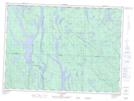
- Atlas of Canada Locator Map: Chutes Matcimanito
- GPS Coordinate Locator Map: Chutes Matcimanito Lat/Long
Chutes Matcimanito NTS Map Sheets