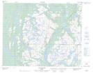
Maps showing Le Rocky Neck, Petit-Mécatina; Minganie, Quebec
Le Rocky Neck is a Valley located in Petit-Mécatina; Minganie, Quebec.
- Latitude: 51° 39' 27'' North (decimal: 51.6575530)
- Longitude: 57° 52' 30'' West (decimal: -57.8749093)
- Topography Feature Category: Valley
- Geographical Feature: Col
- Canadian Province/Territory: Quebec
- Location: Petit-Mécatina; Minganie
- Atlas of Canada Locator Map: Le Rocky Neck
- GPS Coordinate Locator Map: Le Rocky Neck Lat/Long
Le Rocky Neck NTS Map Sheets