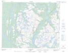
Maps showing Île Longue, Petit-Mécatina; Minganie, Quebec
Île Longue is a Island located in Petit-Mécatina; Minganie, Quebec.
- Latitude: 51° 36' 17'' North (decimal: 51.6047742)
- Longitude: 57° 41' 3'' West (decimal: -57.6840742)
- Topography Feature Category: Island
- Geographical Feature: Île / Ile
- Canadian Province/Territory: Quebec
- Location: Petit-Mécatina; Minganie
- Atlas of Canada Locator Map: Île Longue
- GPS Coordinate Locator Map: Île Longue Lat/Long
Île Longue NTS Map Sheets