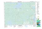
Maps showing Pointe Allison, Lac-Duparquet; Abitibi-Ouest, Quebec
Pointe Allison is a Cape located in Lac-Duparquet; Abitibi-Ouest, Quebec.
- Latitude: 48° 26' 45'' North (decimal: 48.4458332)
- Longitude: 79° 18' 26'' West (decimal: -79.3072222)
- Topography Feature Category: Cape
- Geographical Feature: Pointe
- Canadian Province/Territory: Quebec
- Location: Lac-Duparquet; Abitibi-Ouest
- Atlas of Canada Locator Map: Pointe Allison
- GPS Coordinate Locator Map: Pointe Allison Lat/Long
Pointe Allison NTS Map Sheets