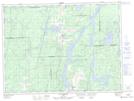
Maps showing Pointe Obikoba, Rémigny; Témiscamingue, Quebec
Pointe Obikoba is a Cape located in Rémigny; Témiscamingue, Quebec.
- Latitude: 47° 46' 15'' North (decimal: 47.7708333)
- Longitude: 79° 14' 34'' West (decimal: -79.2427778)
- Topography Feature Category: Cape
- Geographical Feature: Pointe
- Canadian Province/Territory: Quebec
- Location: Rémigny; Témiscamingue
- Atlas of Canada Locator Map: Pointe Obikoba
- GPS Coordinate Locator Map: Pointe Obikoba Lat/Long
Pointe Obikoba NTS Map Sheets