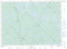
Maps showing Étang du Mulet, Lac-Matawin; Matawinie, Quebec
Étang du Mulet is a Lake located in Lac-Matawin; Matawinie, Quebec.
- Latitude: 47° 1' 5'' North (decimal: 47.0181070)
- Longitude: 74° 20' 8'' West (decimal: -74.3354312)
- Topography Feature Category: Lake
- Geographical Feature: Étang
- Canadian Province/Territory: Quebec
- Location: Lac-Matawin; Matawinie
- Atlas of Canada Locator Map: Étang du Mulet
- GPS Coordinate Locator Map: Étang du Mulet Lat/Long
Étang du Mulet NTS Map Sheets